“Site planning is the art of arranging the external physical environment to support human
behavior. It lies along the boundaries of architecture, engineering, landscape architecture, and
city planning, and it is practiced by members of all these professions. Site plans locate
structures and activities in three-dimensional space and, when appropriate, in time.”
—Lynch (1971, pp. 3–4)
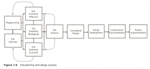
Site-planning and design process (Lagro A. James,17)
Site planning often starts with mapping a project/ site’s opportunities and contrainsts, espcially site’s attributes. A site’s attributes often are Physical attributes, Biological Attributes, Cultural Attributes. Mapping these attributes onto the Land use Suitablility analysis is important in order to understand a site’s assets and liabilities (opportunities and contrainsts).
It is important to note that site analysis is closely linked to the intended programs or uses of a site. Mapping physical, biological, and cultural attributes, alone, is not sufficient for a site analysis.
Site planning also involves Site Selection Scope, which follows a project’s goals, objectives, and program, the latter being a list of program goals that gather information about the site’s context, user needs, and preferences, as well as design precedents. One can obtain information of the site through a variety of methods, such as Intervews, Surveys, Document analysis, Behavioral observation, visiting a case study project, or referencing literatue reviews. To support this programming process, the following documents are needed: Historal and current aerial maps and photographs, Zoning maps, Road maps, Soil maps, Flood hazard maps, and Tax assessment maps.
ASSESSING THE SITE’S PHYSIOGRAPHIC CONTEXT
Base maps
ASSESSING THE SITE’S BIOLOGICAL CONTEXT
Nature’s Infrastructure
Wetlands
Wildlife
Plants
ASSESSING THE SITE’S LAND-USE, INFRASTRUCTURE, AND REGULATORY CONTEXT
Land-use type and Intensity
Property Ownership and Value
Land-use Regulation (State regulations, Local plans and regulations (zoning codes, comprehensive plans etc.), Zoning Overlay Districts, Subdivision Ordinances, Development Codes, Design Guidelines, Covenants, Easements, etc.)
Infrastructure (Transportation, Utilities, etc.)
ASSESSING THE SITE’S CULTURAL AND HISTORIC CONTEXT
Building and Neighborhood Character (Morphology (Lynch: Edges, Paths, Districts, Nodes, Landmarks), Building Character analysis (Facade height, width, proportions, rhythms, materials, colors, Roof form, signs, sidewalks, Setback etc.), Typologies etc.)
Historic Resources
Demographics
Environmental Perception (Visibility, Visual quality, Noise and Air pollution etc.)
References:
LAGRO A. JAMES. Site analysis: Informing context-sensitive and sustainable site planning and Design. JOHN WILEY & SONS; S.l., 2020